


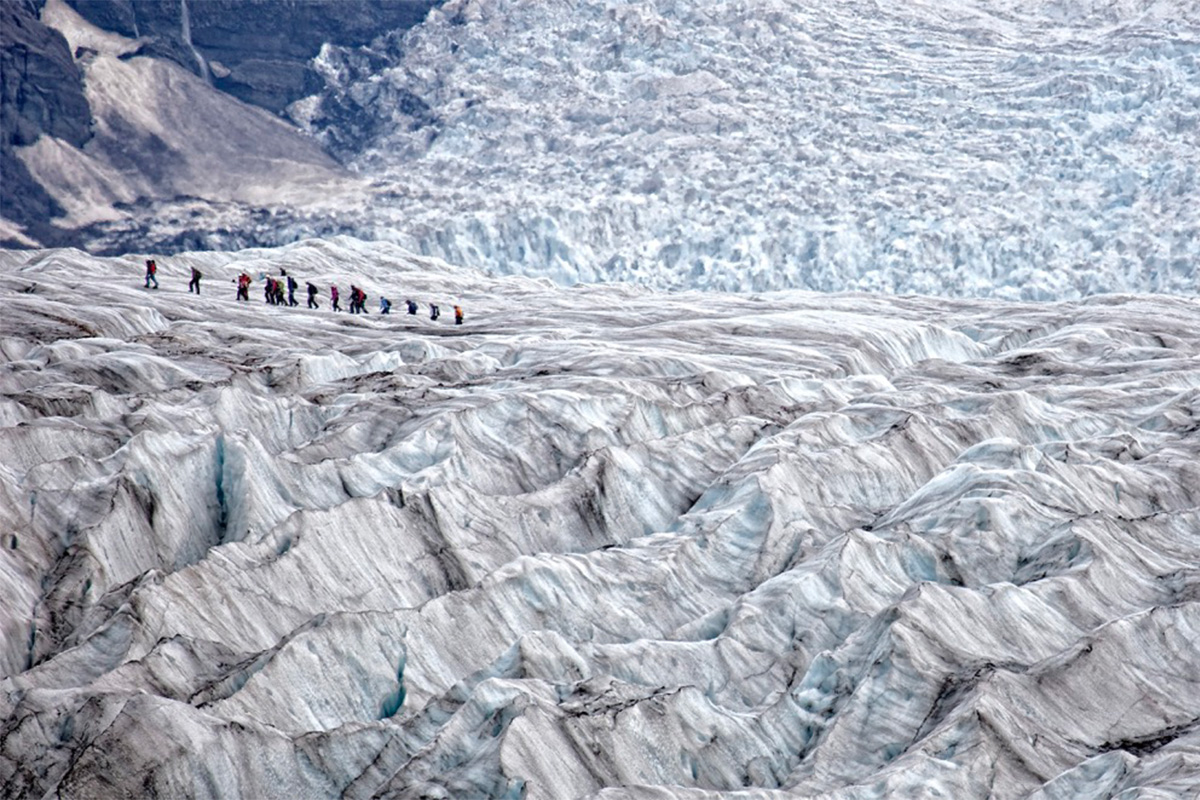
The Vatnajökull ice cap covers circa eight percent of Iceland’s territory and has lost more than fifteen percent of its volume during the last century
Iceland – the land of ice
Iceland (Ísland) is a Northern European island country located between the Greenland Sea and the North Atlantic Ocean. 371,580 people inhabit this nordic country, living over an area of 102,775 km2, with a population density of 3.5/km. Reykjavík is Iceland’s capital city, the country’s largest urban area with its population of 131,136 inhabitants, and the world’s northernmost capital of a sovereign state.
The settlement of Iceland took place in the 9th century when Norse settlers reached the island. According to the medieval Icelandic Landnámabók, the first Norse settler Ingólfr Arnarson set his farm down in what would later become the capital in 874 CE. After the Old Covenant (Gamli sáttmáli) signing between 1262 and 1264, Iceland was united with the Old Kingdom of Norway. The 1387 Kalmar Union unified Iceland and Norway with Denmark. Ceded to Denmark via the Treaty of Kiel, this nordic country became a sovereign state in 1918 and a republic in 1944.
Thanks to the Gulf Stream flowing around the country’s southern and western coasts, the Icelandic climate is milder than its latitude might suggest, with a mean annual temperature of 2.32 °C. The country’s name is related to its abundance of glaciers, which have a total combined volume of 3,400 km3 in 2019.
The mass change of icelandic glaciers
Since the end of the so-called Little Ice Age (LIA) around 1900, Icelandic glaciers have experienced a mass change of −540 ± 130 Gt, with almost half of the total mass loss taking place since 1994/95.
«So far, even with the melting, around ten percent of Iceland is covered by glaciers, and some are very large. Still, they are a small part of the total glaciated areas in the world, including Greenland and Antarctica. Even though the melting of the Icelandic glaciers is considerable, it’s still a drop in the ocean. Yet, if all of the glaciers in Iceland were to melt, that would contribute tens of centimeters to sea-level rise. So far, the change in sea level is not impacting Iceland so much. But this can change, of course. Climate change is a global phenomenon. So for us, it’s the melting of the Antarctic ice sheet that will lead to the greatest sea level rise. The sea-level rise from Iceland and Greenland has, in contrast, had the greatest effect on the southern half of the globe. It’s complicated, and that’s something that describes climate change in a nutshell. It’s complicated because we are tinkering with the Earth´s system, not just individual processes or phenomena». Explained Þorvarður Árnason, the Director of the University of Iceland’s Hornafjörður Research Centre

How has climate change been impacting Iceland specifically?
In recent decades, Iceland has experienced significant warming. Since 1980 the warming rate trend in Iceland has been zero-point-forty-seven degrees Celsius per decade. This rate is several times higher than the global average warming trend. The warming happening in Iceland is more present in the west and north-western areas of the country.
As reported in the Intergovernmental Panel on Climate Change (IPCC) ‘s Working Group I’s contribution to the Sixth Assessment Report (AR6) Climate Change 2021: The Physical Science Basis, in Iceland and Greenland observed change in heavy precipitation indicates an increasing trend. The same goes for hot extremes in the GIC area, as the assessment of observed change in hot extremes shows an increase.
One of the largest in Europe, the Icelandic Vatnajökull ice cap, which covers almost eight percent of the country’s area, has lost 150–200 km³ of its ice, while its area has decreased by more than 400 km². Irreversible thinning impacted the Ok glacier (Okjökull), a glacier located in western Iceland, northeast of Reykjavík until it was declared dead in 2014.
Data in the sea around Iceland from 1984 collected by scientists from the University of Iceland shows that rapid changes in acidity (pH-value) of the ocean north of Iceland have been happening, as ocean acidification happens faster around this country than further south in the globe. The ocean warming around the country has impacted the marine ecosystem and has modified the distribution and abundance in the ocean of several pelagic fish species.
When has this melting phenomenon started manifesting itself?
Since 1880, the global mean sea level has increased by about 210–240 millimeters. Mean sea level increase is caused by the impact of climate change on mountain glaciers, polar ice sheets, and ocean temperatures. Global warming melts mountain glaciers and polar ice sheets, adding water to the oceans. The warming of the oceans and its resulting expansion increases the water’s volume.
On a regional level, other phenomena such as uplift can occur due to the melting of glaciers. In Iceland, where large glaciers such as the Vatnajökull ice cap are going through thinning, areas of the country are experiencing uplift.
An inventory of Icelandic glaciers compiled around 2000 included around 300 glaciers. The updated 2017 inventory indicated that by that year, tens of those initial 300 glaciers have in the meantime disappeared or turned into dead ice.
The uplifting of glaciers
Since their formation, the Icelandic glaciers have been weighing down the areas underneath them. As they melt away and become lighter due to global warming, part of this pressure they exercise is lifted off the ground. The reduction of load on the Earth’s crust causes a rebound effect, as the ground bounces back up, causing uplift.
«The melting of glaciers started about 120/130 years ago. For about 400 to 500 years, the glaciers in Iceland were growing, reaching their maximum size and thickness around 1890. After that, there was a period where the glaciers were relatively stable: they were not growing, and they were not receding much. But then, as we got into the 20th century, it became clear that the glaciers were starting to recede, getting smaller, thinner and shorter. This recession has been ongoing for the last century or so, but it’s been accelerating. It’s picking up speed. There seems to have been a jump around 1990. About half of the glacier melt that we’ve seen since the beginning has happened in the last 30 years. In other words, what previously took almost a century to happen now takes only three decades. This trend is expected to continue, with ever faster rates of recession in coming years.
What are the geographical causes behind the uplift taking place in Iceland? Why are some areas experiencing uplift while the southwest part of Iceland is experiencing subsidence?
Because of the crustal uplift happening due to the melting of the glaciers located in the surrounding area, the region around the Icelandic harbor town of Höfn in Hornafjörður fjord is experiencing a rapid rise.
The continuous GPS Measurements of the crustal uplift in the town of Höfn í Hornafirði show an uplift higher than ten mm/year. Higherstill is the crustal uplift impacting the area South of the Vatnajökull ice cap, where those measurements show an uplift higher than twenty mm/year.
Crustal uplift is impacting in a similar manner the hinterland of the country and the other areas close to the south-east and southern coast.
This phenomenon is not taking place everywhere in the country, as its urban south-western area, where the capital city of Reykjavík is located, is experiencing a phenomenon opposite in nature: subsidence. Measurements of the sea level in the capital indicate that the long-term subsidence has been around 2 mm per year.
«Iceland sits atop two tectonic plates, the North American Plate and the Eurasian Plate, which are gradually pulling apart. So there is uplift in the eastern part, but the western part is subsiding. It’s going down. The situation on the east plate is different because of Vatnajökull, the biggest ice mass in Iceland, which covers an area of almost 8000 square kilometers, and its maximum thickness is close to one kilometer. It’s a huge block of ice, and this ice was growing for a period of four to five centuries during the so-called Little Ice Age. As the ice grew, it put pressure on the land, so the land subsided. It went down because of the increased weight of the glacier ice. When the glaciers start to recede and melt away, then the reverse happens as the weight of the ice mass decreases. So the land rebounds, and it starts to move».
Could these land changes impact volcanic activity?
Iceland is one of the many areas around the globe characterized by volcanic activity impacted by climate change. In 2017 Geology published a study investigating climatic control on the volcanic activity in Iceland during the mid-Holocene, conducted by a group of researchers from the University of Leeds, the University of St Andrews, and the University of South Florida. The study showed that the frequency of volcanic eruptions in Iceland was influenced by the glacial extent, which is impacted by the climate. In fact, a period between 5,500 to 4,500 years ago and characterized by reduced volcanic activity in Iceland was preceded by a time of glacial advance in the country.
«Iceland, unlike most, if not all other countries, has a pronounced interaction between volcanic activity and glacial activity. The Vatnajökull ice cap sits atop nine active areas, either volcanic or geothermally active. Amongst them are some of the biggest volcanoes in Iceland, and a blanket of glacier ice covers them. As the glacier ice melts, this blanket of ice on top of the volcanoes becomes thinner and thinner. This means that for the magma, which later becomes lava, coming from the Earth’s mantle or crust, it becomes easier to break through. As the glacier thins, the likelihood of these outbursts breaking through the ice becomes higher». Said Árnason.
Þorvarður Árnason
Director of the University of Iceland’s Hornafjörður Research Centre since 2006. Árnason has a Ph.D. in interdisciplinary environmental studies.